

Severe Studios
Friday, October 29, 2010
My Weekend: Texas Supercells 10-22-10 + SPC High Risk 10-26-10
Starting just before 3:00, we were extremely close to a rain-wrapped tornado near Cridersville, Ohio. The debris you see flying towards the car is pieces of paper from insulation.
Tuesday, October 26, 2010
High Risk for most of Indiana!
Today is shaping up to be a possibly record-breaking and extremely dangerous day. SPC has issued a rare October High-Risk. The main threat today should be extreme and widespread damaging winds, but isolated tornadoes are also expected. There is a threat of strong to violent tornadoes as well, especially with any storms that are able to remain discrete. Stay tuned to news and media outlets through the morning and listen to your NOAA Weather Radio for the latest watch and warning updates.
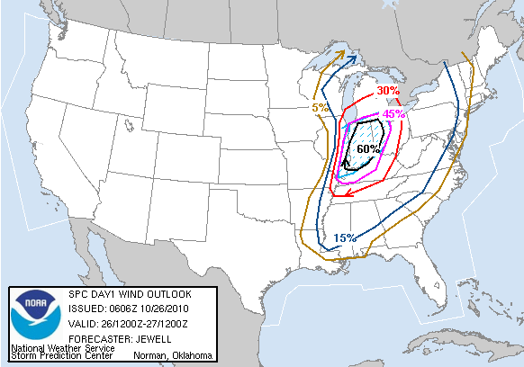 | ||
| Probabilistic Damaging Wind Graphic |
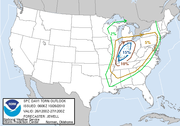 |
| Probabilistic Tornado Graphic (blue hatched area: 10% or greater chance of significant tornadoes rated ef2 to ef5) |
Monday, October 25, 2010
Tornado watch issued for much of the Midwest!
This could potentially be an extremely dangerous situation. Stay alert tonight, And take cover if any warnings are issued.

Illinois upgraded to a moderate risk!
Things are panning out for a significant weather event to occur over much of Illinois and surrounding areas through tomorrow morning. This situation could be particularly dangerous given it will be ongoing across Illinois during the hours of the morning commute. Make sure to keep a close eye on the weather and take severe weather warnings seriously! This is not your everyday severe weather event.

Severe weather outbreak continues Tuesday for portions of the Midwest and Ohio Valley!
The same front expected to move through Illinois and surrounding areas tonight may produce a significant severe weather outbreak tomorrow. Isolated tornadoes will be possible especially with any storms that may be able to remain discrete. This could be a dangerous day for people in Illinois, Indiana, Michigan, Ohio, and Kentucky. People in these areas should exercise caution and keep an eye on the latest weather reports and listen to the latest reports on NOAA Weather Radio.

Nocturnal severe weather event likely for portions of the midwest!
T-storms are expected to develop late tonight/tuesday morning along a cold front associated with a rather strong low pressure system tracking across the country. Although the main threats will be extremely strong straight line winds, a few tornadoes will... be possible overnight with any supercells embedded in the line. Make sure to keep updated on this event if you are in the affected area.

Saturday, October 23, 2010
Texas Chase 10-22-10
Thursday afternoon, I decided to leave work early and make the 12.5 hour trip from Rockford, Illinois to Norman, Oklahoma to meet up with Joe Navickis and Juston Drake to take a shot at a possible chase day Friday. After arriving in Joplin, Missouri and taking a short nap, I was back on the road for Norman.
I arrived around 10 am, and we headed out right away. Things weren't looking quite as good at this point, but we abandoned our original target in the Texas Panhandle for a more probable target, being it didn't appear there would be sufficient instability in the Panhandle region.
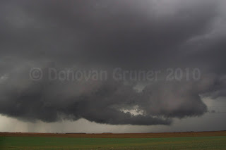
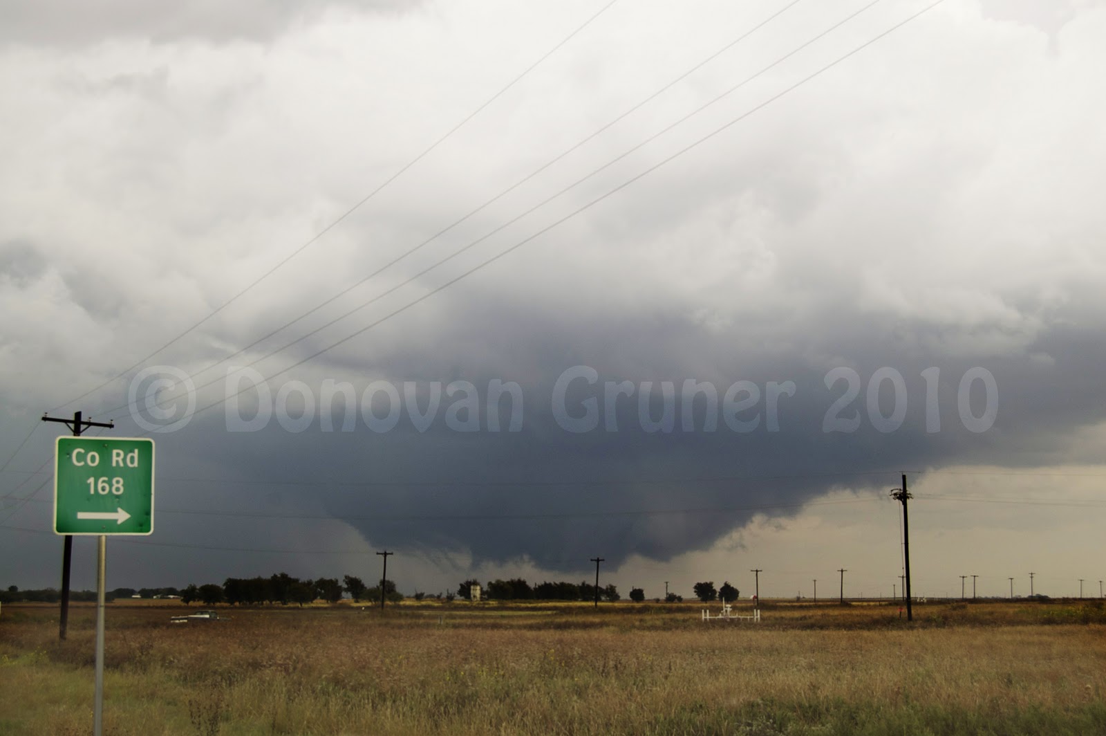
Passing through the morning convection coming out of W TX/SW OK, we were treated to a nice shelf cloud on a line of storms, but never mind that. Targeting near Childress, Texas, we made it down in time for storms to start developing to our SW. One isolated cell began to develop, so we set course for intercept. The storm had been severe warned, and another storm was developing to its NE.
Although the storm to the NE had a nice looking wall cloud, the base on the storm approaching from the south was much more impressive looking, so we decided to stick with it. As it approached, we were treated to some very nice structure and intense cg's, and soon a few brief rope funnels. The storm quickly became outflow dominant, and choked itself off. This storm came very close to producing, but never became tornado warned.

I arrived around 10 am, and we headed out right away. Things weren't looking quite as good at this point, but we abandoned our original target in the Texas Panhandle for a more probable target, being it didn't appear there would be sufficient instability in the Panhandle region.
Passing through the morning convection coming out of W TX/SW OK, we were treated to a nice shelf cloud on a line of storms, but never mind that. Targeting near Childress, Texas, we made it down in time for storms to start developing to our SW. One isolated cell began to develop, so we set course for intercept. The storm had been severe warned, and another storm was developing to its NE.
 |
| Wall cloud on northern storm |
 |
| Southern storm approaching |
Although the storm to the NE had a nice looking wall cloud, the base on the storm approaching from the south was much more impressive looking, so we decided to stick with it. As it approached, we were treated to some very nice structure and intense cg's, and soon a few brief rope funnels. The storm quickly became outflow dominant, and choked itself off. This storm came very close to producing, but never became tornado warned.


Subscribe to:
Posts (Atom)