

Severe Studios

Monday, May 27, 2013
Severe Weather Outbreak Likely In Kansas This Afternoon
Currently heading towards, Salina, KS to get in position for a potential severe weather outbreak this afternoon. Things seem to be shaping up nicely for a fairly localized tornado outbreak along the warm front/triple point in N Kansas. Stay tuned to SevereVideos.com and TVNWeather.com for live streaming video and updates!

Monday, March 25, 2013
First Chase May Be About A Week Away!!!
With the beginning of Spring 2013 starting off very cold due to the infamous "Greenland Block" pattern keeping much of the continental US below average temperature-wise, there has been a much below normal amount of severe weather in the month of March so far this year. Models are finally beginning to agree that temperatures across the country will begin to rise this week... and possibly be back to or above normal by this weekend!
Although still a week out, and still too far away to make a detailed/confident forecast, a few days early next week have my attention. The last few GFS runs have shown a system developing early next week that could potentially bring a severe weather threat to the Texas Panhandle, Western Oklahoma, up through Western Kansas and Nebraska.
There is also some promise for this system to be a multi-day severe weather episode, possibly towards the Mid-Mississippi Valley area by Wednesday.
Although the latest model runs have got many storm chasers like myself drooling over the possibility of finally getting out on the road next week, it is FAR too early to be making any concrete plans. For example, the system I have talked about was an entire day earlier in previous model runs. Basically, just the fact that a decent looking system showing up in the models for next week is enough to get me excited at this point, just for the fact that it means there is a chance for a chase or two!
Stay tuned for further updates!
Donovan
Although still a week out, and still too far away to make a detailed/confident forecast, a few days early next week have my attention. The last few GFS runs have shown a system developing early next week that could potentially bring a severe weather threat to the Texas Panhandle, Western Oklahoma, up through Western Kansas and Nebraska.
 |
| GFS Forecast Surface Dewpoints, Tue April 2nd, 18z (1:00 PM) |
 |
| GFS Forecast Surface Dewpoints, Tue April 3rd, 18z (1:00 PM) |
Stay tuned for further updates!
Donovan
Wednesday, March 6, 2013
Photos of 2012
Although 2012 proved to be a real test to the sanity of storm chasers and severe weather junkies nationwide, it was not without its opportunities to snap a few nice shots.
Here is a few of my favorites from 2012.


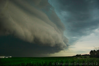


Here is a few of my favorites from 2012.


Monday, April 30, 2012
5/1 and 5/2 Severe Potential
Tomorrow it appears an active period of weather will begin across parts of the Northern Plains and Upper Mississippi River Valley. This active pattern will usher in much warmer temperatures to much of the Midwest to kick of the month of May. Along with the warmth, ample moisture will be present to fuel several rounds of severe weather.
For Tuesday, it appears storms may begin to develop along a dryline/cold front over parts of eastern South Dakota, Nebraska, west Iowa, and Minnesota. Many of these storms may be severe, however tornadic potential is fairly unclear at this point. There is also a slim chance that more discrete activity could develop further south across parts of Kansas.
Wednesday could be a fairly interesting day, given several outflow boundaries may be left behind by Tuesday's storms. This could provide additional focus for storm development, as well as enhanced tornado potential in some areas, namely over parts of central Iowa.
I will be out tomorrow and likely Wednesday, and will be streaming live at www.chasertv.com.
Donovan Gruner
For Tuesday, it appears storms may begin to develop along a dryline/cold front over parts of eastern South Dakota, Nebraska, west Iowa, and Minnesota. Many of these storms may be severe, however tornadic potential is fairly unclear at this point. There is also a slim chance that more discrete activity could develop further south across parts of Kansas.
Wednesday could be a fairly interesting day, given several outflow boundaries may be left behind by Tuesday's storms. This could provide additional focus for storm development, as well as enhanced tornado potential in some areas, namely over parts of central Iowa.
I will be out tomorrow and likely Wednesday, and will be streaming live at www.chasertv.com.
Donovan Gruner
SevereVideos.com
Alright, so I haven't done anything with this blog for just over a year, but I am starting back up! This will be my temporary site until the new "severevideos.com" site is ready.
The next few days hold the possibility of being decent chase days in the Midwest/Great Lakes regions, so later I will be posting a bit about that. May be heading out tomorrow morning for MN/IA, depending on 00z model runs and forecast trends.
I am also using Twitter again (@donovangruner), and will be trying to keep this stuff as updated as possible while chasing.
Donovan Gruner
The next few days hold the possibility of being decent chase days in the Midwest/Great Lakes regions, so later I will be posting a bit about that. May be heading out tomorrow morning for MN/IA, depending on 00z model runs and forecast trends.
I am also using Twitter again (@donovangruner), and will be trying to keep this stuff as updated as possible while chasing.
Donovan Gruner
Wednesday, April 13, 2011
April 8th - 11th, Thoughts on April 14th - Tornado Outbreak Possible
 |
| Chaser convergence at Pizza Hut |
Last Friday, I headed out on a 3 day chase adventure with Brandon Sullivan and Connor McCrorey. We targeted a bit southwest of the OKC area, being models were showing a discrete supercell firing to the southwest. We stopped in El Reno for some pizza before the chase, and met up with Tony Laubach, Colt Forney, Kevin Rolfs, Scott Peake, and others. Towers began to go up shortly after finishing our pizza, and we decided to head northeast.
After sitting in a field watching towers trying and dying, I began to get a little nervous. However, a tower just to our west was able to break the cap, and rapidly became a monsterous supercell.

This storm was a very beautiful storm, however it just didn't have what it took to produce. It came very close for a little bit, and despite the plethora of reports of funnel clouds and rapidly rotating wall clouds, OUN didn't seem to want to tornado warn it.
 |
| This should probably be tornado warned... |

After watching this beast for a few hours, it became apparent it probably wasn't going to produce. However, it did drop a good sized swath of 3"+ hail, and was very photogenic. We eventually decided to start heading north to set up for Saturdays target, but got sidetracked shooting lighting. As we were shooting lightning, the storm we were shooting went tornado warned. We decided to head a bit south and west to check it out.
 |
| N Oklahoma Tor Warned Supercell around 10 PM |
We made it to Topeka early Saturday morning, and slept a few hours. We then headed to Omaha to pick up Brett Wright from the airport. We then decided to get Pizza Hut again, being we'd had luck every time we had eaten there before a chase. We looked over data over a few pizzas, and headed out. After watching a Cu field on satellite for a while, we began to see the towers in the distance. We decided to head a bit closer to get a better look. We watched one of the towers begin to dominate, and eventually grow into a monster supercell just NW of Omaha.
After going through a few splits, the right split seemed to be getting it's act together. It strengthened, and then rooted itself into the warm front. It then turned hard right, and began to look like it may produce. We stopped in Mapleton, Iowa for a fill up, and the storm went tor warned. We headed a bit to the west to get a better look, and may have seen a few brief spin-ups. The inflow at our location was so strong, it ripped the drivers door open, and bent the hinges. We couldn't get the door shut, so I ended up tying it shut with my shoelaces in hopes of salvaging at least one tornado.
Video shot by Brandon Sullivan Wicked Wind Media
Shortly after the door incident, we found ourselves watching a nice cone funnel come down with a little dust getting kicked up underneath. It rapidly intensified, and became a 3/4 mile wide EF3. Unfortunately, it hit the town of Mapleton, where we had just filled up. We decided to head into town to see if we could do anything to help, and try to figure out a way to fix the door for Sunday's chase.


Later on, we got some absolutely incredible structure. The storm eventually produced several tornadoes for us, but the amount of trees made it nearly impossible to shoot any photos or video. NEVER EVER CHASE IN NORTH WISCONSIN UNDER ANY CIRCUMSTANCES EVER!!! After seeing what appeared to be a huge wedge cross a few miles in front of us, we decided to just about give up... when we got a radar update showing an intensifying couplet just to our west. We sat still and watched a wall cloud spin across the road in front of us, but it just couldn't put anything down. Due to a lack of roads and how far north we were, we decided to call off the chase and begin heading south to Rockford to stay at my parents house.
It was a great weekend, however it could have gone better. Unfortunately due to the door issues Saturday, we missed 10+ tornadoes after dark, including a violent wedge, twin stovepipes, and a multi-vortex tornado. I've even heard rumors that there was 3 tornadoes on the ground at one point. That storm is definitely one of the most powerful storms I've ever witnessed... and is likely one of the most powerful on record. Congratulations to everyone who got some amazing video and pictures of these spectacular nighttime tornadoes! At least I got to end the trip nicely by spending a night at home and seeing my best friend, Sputnik!
 |
| Sputnik |
It now appears that tomorrow could be a fairly significant severe weather outbreak across parts of the Southern Plains/Ozarks. A line of discrete supercells could develop along a dryline from SE Kansas to NE Texas in the evening. Tornadoes, some strong, are possible with any supercell that is able to develop. Potential may ramp up a bit towards sundown due to a strengthening low level jet around 00z to 01z. I currently like Central to East Central Oklahoma due to the positioning of the jet max, enhancing lift due to the left exit region over this area. SPC has issued a Moderate Risk, and I've been having good luck with those lately. If you live in areas affected by this system, pay attention to watches and warnings and stay tuned to local news or NOAA weather radio for more info.
Donovan Gruner
Tuesday, April 5, 2011
One of the Biggest Severe Weather Events of All Time

This weekend appears that it will be another active weekend. Things will likely kick off in the Central Plains on Thursday, and several rounds of action on the dryline are expected through Sunday. At the moment it appears the threat could reach from Texas, Oklahoma, and Kansas up to Illinois, Iowa, Missouri, and Indiana. More updates to come as the event draws near.
Donovan Gruner
Monday, April 4, 2011
April 3rd, 2011 NE Kansas Chase
 |
| Supercell West of Topeka, KS |
 |
| Just west of Lawrence, KS... Base becoming visible to the left. |
 |
| Gustnado near |
 |
| This is the first storm we were on. A classic supercell, you can see it modifying the cold front to allow for inflow to come from the warm sector. This radar image is roughly 15 minutes before the gustnado was observed. |
After the first storm began to move into the KC Metro area, we decided to intercept some hailers developing along the cold front/dryline.
This was a very fun chase, with some very photogenic moments. I just regret not trying to get closer to the gustnado!
Donovan Gruner
Saturday, April 2, 2011
Tornado Outbreak Potential Tomorrow- N Illinois to N Texas
 |
| S WI 7-22-10 |
It is beginning to appear that tomorrow's potential outbreak could be more widespread than initially thought. With moisture streaming further northward, the potential for tornadoes could reach as far as Northern Illinois. The main question of the day remains the location where the cap might be able to break due to a temperature inversion around 700mb.
 |
| CAPE 00z Monday |
At the moment it appears the two most likely areas for diurnal convection may be from E Iowa/N Illinois and E Kansas. However, if the cap should break Sunday evening anywhere from N Texas to Iowa, supercells will be possible with tornadoes and large hail.
 | ||
| 0-3 km Energy Helicty Index 00z Mon |
 |
| SREF Sig Tornado Ingredients Parameter targeting N Illinois |
 |
| NAM Sig Tornado Parameter targeting SE Kansas, NE Oklahoma, and N Illinois |
At the moment I am partial to E Kansas due to it being close to a triple point and a more realistic chasing target for me. However, I do like the potential in N Illinois. If it wasn't for classes on Monday, I would want to chase on my favorite terrain/road network in the country in N Illinois.
This could potentially be a significant outbreak, so people across the Midwest and Central/Southern Plains need to be paying attention and reviewing severe weather safety before this event. Stay tuned to local news outlets and NOAA weather radios for up to the minute details.
Donovan Gruner
Thursday, March 31, 2011
Significant Severe Weather Possible This Weekend and Likely Next Week
 |
| Damage in Yazoo City, Missisippi in April of 2010 from an EF-4 tornado with a path length of 149 miles |
Saturday may bring a chance for a few severe storms in N TX. These storms would likely be supercellular structures, and would have the potential to produce very large hail, and less likely an isolated or possibly few tornadoes. The main question at the moment is if enough moisture will be available in the area with the greatest potential, and if the cap will be able to break before nightfall when convective inhibitation will substantially increase and likely kill off any storms that may form during the afternoon hours.
Sunday may also pose the threat for supercells along the dryline from southcentral to southeast Kansas through Central/East Oklahoma down to Central/East Texas. This setup has much more potential than Saturday, however the cap seems to be the main question for this setup as well. Any storms that form along the dryline will likely be extremely powerful supercells, and will have the potential to produce very large hail given CAPE possibly reaching 3000+ j/kg, and tornadoes- possibly strong, due to good wind shear and the high CAPE values along and ahead of the dryline. Again, the main question is if storms will be able to develop due to 700mb temperatures being on the high side, forming a capping inversion.
As of now, it appears a large and very dangerous tornado/severe weather outbreak is likely Monday across parts of the Arklatex reigion into Dixie Alley. This setup could potentially be the first high risk setup of 2011. Strong wind shear of 50+ kts and CAPE values exceeding 2000 j/kg should be enough to support supercells and bowing segments capable of producing large hail, damaging winds, and isolated tornadoes. Over parts of Dixie Alley, 850mb winds could be in excess of 50+ kts, pointing out the extreme energy this system will have. This severe weather event could even effect areas as far as Ohio, Indiana, Kentucky, Tennessee, and Illinois. This could be an especially dangerous day, so people need to pay attention to what is going on. As Monday comes closer, details will become more apparent, resulting in greater confidence in the forecast.
This system will likely continue to produce severe weather across the south into New England Tuesday and Wednesday before exiting into the Atlantic. If you live in any of the affected areas, stay tuned to later forecasts and listen to NOAA Weather Radios and local news for more details regarding this event.
Donovan Gruner
Tuesday, March 22, 2011
Severe Weather Expected From Central Plains to Midwest
Severe weather including tornadoes is possible today from parts of Kansas, Nebraska, Missouri, and Iowa. Unlike previous days, it appears that stronger forcing and lower temperatures aloft will allow for the cap to be broken. A low pressure system/triple point will move into NE Nebraska and W Iowa by this afternoon, bringing the greatest severe weather potential due to veering low level winds near the triple point to the area.
Low level helicity will be maximized by low level veering winds near the triple point, bringing the greatest tornado potential to SE Nebraska, NE Kansas, extreme N Missouri, and much of Iowa.

By 19-21z (2-4 pm CDT) storms are expected to be developing along the dryline from E Nebraska down through NE Oklahoma. The greatest tornado potential will be with any storms that are able to remain discrete for a while after development. Strong forcing associated with a shortwave trough may be conducive of a more dominant bow echo mode towards evening and sunset. This will shift the primary threat from large hail/tornadoes to damaging winds, which with some large hail could persist into the night through Iowa and N Missouri into Illinois. This system could also bring significant severe weather to parts of the East Coast tomorrow.
Later in the week could bring more severe weather from parts of the southern and central plains, bringing more opportunities to chase Thursday through the weekend.
Donovan Gruner
 |
| 300+ 0-1 km Helicity Across much of the risk area |
Low level helicity will be maximized by low level veering winds near the triple point, bringing the greatest tornado potential to SE Nebraska, NE Kansas, extreme N Missouri, and much of Iowa.
 |
| Maximized instability near triple point |

By 19-21z (2-4 pm CDT) storms are expected to be developing along the dryline from E Nebraska down through NE Oklahoma. The greatest tornado potential will be with any storms that are able to remain discrete for a while after development. Strong forcing associated with a shortwave trough may be conducive of a more dominant bow echo mode towards evening and sunset. This will shift the primary threat from large hail/tornadoes to damaging winds, which with some large hail could persist into the night through Iowa and N Missouri into Illinois. This system could also bring significant severe weather to parts of the East Coast tomorrow.
Later in the week could bring more severe weather from parts of the southern and central plains, bringing more opportunities to chase Thursday through the weekend.
Donovan Gruner
 |
| SPC Tornado Probs |
Wednesday, March 9, 2011
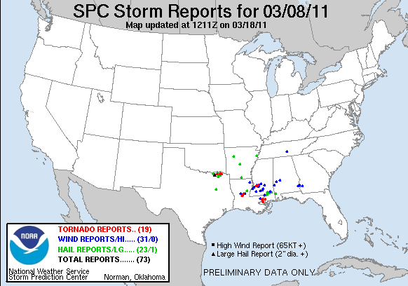
March 8th, 2011 N Texas Storm Pictures
 |
| First lightning shot of 2011! |
 |
| First hailstone to hit me in the noggin in 2011 |
  | ||||||||||
Sunday, March 6, 2011
Pictures from the February 27th, 2011 Northern Oklahoma Supercell
Last week we headed out to N Oklahoma for the first chase of 2011. Rang in the new chase season with a beautiful supercell that formed in NW OK and moved along a warm front into S C KS. This storm produced a tornado near the OK/KS border just east of I-35. Unfortunately due to bad roads, we were unable to keep up with this beast being it was moving between 50-55 mph at that point. All in all, it was a great day to start off the 2011 storm season.


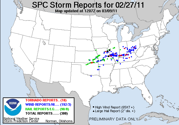 |
| Storm Reports from 2/27/11 |
Subscribe to:
Posts (Atom)