CHASECAM

Severe Studios

Tuesday, March 22, 2011

Severe Weather Expected From Central Plains to Midwest

    Severe weather including tornadoes is possible today from parts of Kansas, Nebraska, Missouri, and Iowa.  Unlike previous days, it appears that stronger forcing and lower temperatures aloft will allow for the cap to be broken. A low pressure system/triple point will move into NE Nebraska and W Iowa by this afternoon, bringing the greatest severe weather potential due to veering low level winds near the triple point to the area.

300+ 0-1 km Helicity Across much of the risk area

    Low level helicity will be maximized by low level veering winds near the triple point, bringing the greatest tornado potential to SE Nebraska, NE Kansas, extreme N Missouri, and much of Iowa.

Maximized instability near triple point


    By 19-21z (2-4 pm CDT) storms are expected to be developing along the dryline from E Nebraska down through NE Oklahoma. The greatest tornado potential will be with any storms that are able to remain discrete for a while after development. Strong forcing associated with a shortwave trough may be conducive of a more dominant bow echo mode towards evening and sunset. This will shift the primary threat from large hail/tornadoes to damaging winds, which with some large hail could persist into the night through Iowa and N Missouri into Illinois. This system could also bring significant severe weather to parts of the East Coast tomorrow.

   Later in the week could bring more severe weather from parts of the southern and central plains, bringing more opportunities to chase Thursday through the weekend.

Donovan Gruner

SPC Tornado Probs

Wednesday, March 9, 2011

March 8th, 2011 N Texas Storm Pictures

First lightning shot of 2011!
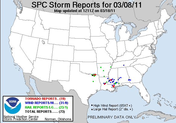
   Another chase opportunity before heading home for spring break.  Headed out from Norman a little after noon (later than planned) and set a target of Sherman, TX to allow a little cushion to the west, since I expected storms to initiate just west of I-35 in N Central Texas.  Because of the late start, had to play catch-up with the storms as they developed slightly earlier than I had anticipated.  Once I finally caught up, it didn't take long for stuff to get interesting.

First hailstone to hit me in the noggin in 2011
   The first storm I got on was actually originally just a core punch to get into position for a more southern cell I was interested in.  Shortly after I began driving into the storm, the NWS slapped a Severe Thunderstorm Warning on it.  It produced gobs and gobs of dime to nickel sized hail, and torrential downpours.  After a while, stuff started looking more interesting on radar, so I decided to stick with it for a bit.  Eventually, I got into what there was of a "bears cage," and found a decent lowering.  It, however, did not appear to have much, if any, rotation at this point.  Within ten minutes of that, there was a rapidly intensifying couplet nearby, and giant hail began to fall.  The stone pictured above is the one that hit me in the head while trying to pick up a bigger stone from my open car door.  Some were around 2.5 to 3 inches, judging by what I could see on the ground.  One managed to put a small crack in my windshield, but luckily no more than just a small crack.  Also experienced some extreme winds, likely associated with a tornadic circulation/RFD, just to the west of Paris, TX.  There was a bit of damage done in the area of Paris to a small farm house and a barn. At this point I decided it would be too dangerous to continue being there was no paved roads to get further south of the storm, and it appeared to be completely rain-wrapped. If storms had stayed more discrete, there is no question in my mind that there could have been several more tornadoes, and a much better chase opportunity.


Sunday, March 6, 2011

Pictures from the February 27th, 2011 Northern Oklahoma Supercell


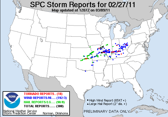
   Last week we headed out to N Oklahoma for the first chase of 2011.  Rang in the new chase season with a beautiful supercell that formed in NW OK and moved along a warm front into S C KS.  This storm produced a tornado near the OK/KS border just east of I-35. Unfortunately due to bad roads, we were unable to keep up with this beast being it was moving between 50-55 mph at that point. All in all, it was a great day to start off the 2011 storm season.


Storm Reports from 2/27/11

Saturday, February 26, 2011

Another Bout of Severe Weather Likely for the Southern Plains/Dixie Alley

Another strong system is moving into the Southern Plains and bringing 
with it chances for severe weather, including damaging winds, large 
hail, and strong tornadoes. There will also be a threat for extreme 
fire danger in the Texas Panhandle region into West Oklahoma behind 
the dryline.
 
  The main question remains the timing of this event. The warm sector 
will remain capped throughout much of the day; however it appears that
a corridor of CAPE values around 1000-1250 j/kg may be sufficient to 
break the cap before sundown. In this event, there is a threat for 
isolated tornadoes and very large hail, especially on storms that form 
early, as they will likely remain isolated until a short time after 
sundown. The system is then expected to expand in coverage and likely 
quickly evolve into a QLCS type system,much like Thursday night's event. 
There will then be a threat for mostly widespread damaging winds, however 
a tornado threat should exist well into the night with any semi-discrete 
or embedded supercells in the line. This could once again be a very 
dangerous evening/night for parts of the Southern Plains and Mid-
Mississippi River Valley into Dixie Alley.


Thursday, February 24, 2011

Severe thunderstorm watch for w texas and west and central oklahoma until 11 am

Tuesday, February 22, 2011

First Major Severe Weather Outbreak of 2011 Possible Thursday!

System drawing moisture from the Gulf
It appears probable that a fairly significant severe weather outbreak is taking shape for Wednesday night into Thursday. A low pressure system will move through the Southern Plains into Dixie Alley Wednesday night into Thursday afternoon and evening. It appears an early round of thunderstorms across W Oklahoma could will develop Wednesday night, and move across the state through morning. This first round of storms main threat will be large hail and possibly damaging winds. Thursday afternoon, storms are expected to form ahead of a dryline bulge and along a warm front across E Oklahoma. Along with large hail and damaging winds, isolated tornadoes will be possible with these storms. At the moment, it appears the greatest threat for severe weather will begin in Central Oklahoma and move across the state into Arkansas. The severe weather threat could continue eastward overnight, although instability will be limited, so the main threat will probably be damaging winds. Stay tuned for further information regarding this event.

Day 3 Convective Outlook Valid Thursday, 2/24

Tuesday, February 8, 2011

Another Round of Snow Expected for the Southern Plains

    Another round of snow is expected today through tomorrow in parts of Kansas, Oklahoma, and Texas, as well as surrounding areas. This comes a week after the crippling snowstorm that hit the same areas, making travel nearly impossible last week. Just as these areas recovered, there may be a significant snowfall tonight through tomorrow afternoon as well. The heaviest snow is expected to be in areas of Southern Kansas into Central Oklahoma, where 6 to 10 inches of snow is possible, with isolated areas receiving up to a foot of snow.

    Although this could be a fairly major storm, there does seem to be some hope for warm weather. Temps are expected to rise into the lower to mid 60's by Sunday, and continue through next week. This will bring much needed relief to areas affected by this storm and last weeks storm.

    If traveling in any of the affected areas tonight or tomorrow, use extreme caution, and stay updated on the latest weather forecasts.

Donovan Gruner