CHASECAM

Severe Studios

Monday, January 31, 2011

"Snowpocalypse". Historic Storm Upon Us?

    This could be a record breaking or near record breaking storm for much of the country.  Latest model runs put a band of extremely heavy snow over Central Oklahoma into SE Kansas. Some areas from Oklahoma City to Chicago are expected to receive at least a foot of snow, and locally some areas may receive up to 2 feet! Strong winds will also complicate things, and areas that receive the highest amounts of snow could see snow drifts up to 8 feet or more. Blizzard Warnings are in effect in 7 states, and reach from Oklahoma City to Chicago and Milwaukee.


    The southern edge of the storm will bring significant icing to areas along the I-44 corridor in Oklahoma and especially Missouri. The ice threat also stretches across Illinois to New England. Some of the hardest hit areas will be St. Louis, Indianapolis, and Pittsburgh.

Ice Accumulations Through Wednesday

    This is a very dangerous storm, and many areas can expect major power outages along with incredibly heavy snow, freezing rain, sleet, and bitter cold wind chills. Several states including Oklahoma, Missouri, and Illinois have been declared to be in a State of Emergency. Stay tuned to your local news and NOAA Weather Radios for up to date details on the storm, and DO NOT travel unless ABSOLUTELY neccesary. If travel is unavoidable, dress in layers and bring food, water, and blankets in case you become stranded. This is a life threatening situation.

What the NWS has to say in it's Forecast Discussions:
   
      Norman, OK: Obvious analog would be Christmas Eve '09. For some this may be as bad or worse.  (That was Okla. City's record snowy day...13.5")
   
      Kansas City, MO: "This could end up being one of the more significant weather events in the last 20 years in Missouri."
   
      St. Louis, MO: "Potentially historic winter storm headed for region."
   
      Milwaukee, WI: Potentially "paralyzing blizzard" possible in southeast Wisconsin. Jan. 1999 blizzard produced 4-8 foot drifts!
   
      Grand Rapids, MI: "Travel...and commerce in general...could be paralyzed with near record-breaking snowfall."
   
      Indianapolis, IN: "(Ice and blizzard conditions) could result in devastating conditions for central Indiana. Long duration power outages appear possible."

Donovan Gruner

Sunday, January 30, 2011

Extreme Winter Storm to Impact Much of the Country

     Strong disturbances associated with two jet streams will develop into a major winter storm for much of the country on Monday through the week. The jet stream is bringing very cold arctic air down from Canada and kicking off the storm by bringing moderate snowfall amounts to much of the Northern Plains and Great Lakes regions. To the south, a wintery mix will begin Monday night in the Oklahoma Panhandle and Southern Kansas before spreading eastward into Missouri. Snow will then begin falling over parts of Central Oklahoma Monday night into Tuesday. 

     A PDS (Particularly Dangerous Situation) Winter Storm Warning is in effect for Central and Northeastern Oklahoma.

     A Blizzard Watch is in effect for much of Northern and Central Illinois and Northwest Indiana, where strong winds and extremely heavy snowfall rates will combine to produce blizzard conditions. As much as 20 inches of snow at a rate of 3 inches per hour are possible in these areas.

GFS showing snow depth by Tuesday afternoon

NAM showing more extreme snowfall totals up to 20+ inches from Central Oklahoma through Missouri, Illinois and Michigan

Wednesday, January 26, 2011

Warm Air to Invade Southern Plains


Models are showing a "heat wave" moving into the Southern Plains at the end of the week, showing temperatures up to 70 degrees in many parts of Oklahoma and Texas. However, they are also showing a possible cold streak next week, with a possibility of a period of wintery precipitation.

Monday, January 24, 2011

November Tornado In N. Illinois As Shown By Radar


Photobucket

    Northern Illinois is beginning to grow accustomed to strange out of season tornadoes. On January 7th, 2008, an EF-3 tornado with wind speeds as high as 160 mph ripped through Boone and McHenry Counties.  Then, on November 22nd, another strange out of season tornado touched down, in nearly the same place. Had it touched down earlier, however, we may have had an entirely different situation on our hands.

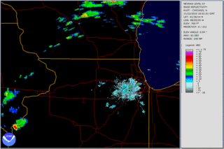
11/22 tornadic supercell with visible BWER (bounded weak echo region, area of lower reflectivity sw of Loves Park and nw of Rockford) associated with the storm's updraft, and sometimes a precursor to tornadogenisis.


    These radar images (Storm Relative Velocity) depict the motion of particles within the storm. The doppler radar is able to detect this the same way as a police radar detects the speed of a vehicle. Meteorologists are able to use this product to detect rotation within thunderstorms, and sometimes detect tornadoes.


    This is the SRV at 2:51 pm. Although the radar is picking up some rotation just northwest of downtown Rockford, there is no tornado warning, possibly because the rotation isn't quite strong enough to validate a warning at the time. HOWEVER:

     Seen here is the same storm, but viewed at a higher elevation, ten minutes earlier (2:41 pm). There is very strong rotation at around 13kft, just southeast of Winnebago.

      Here you can clearly see the meso tighten up. This is at about 6,500 ft. The velocity couplet is now exhibiting strong maxed out velocities in both directions. This image is at about 2:56 pm, four minutes before the tornado warning was issued.
      At 3:00 pm, the NWS Chicago issued a tornado warning for Winnebago, Boone, and McHenry counties...

THE NATIONAL WEATHER SERVICE IN CHICAGO HAS ISSUED A* TORNADO WARNING FOR...
NORTHERN BOONE COUNTY...
NORTHWESTERN MCHENRY COUNTY...
EAST CENTRAL WINNEBAGO COUNTY...
* UNTIL 330 PM CST
* AT 300 PM...NATIONAL WEATHER SERVICE DOPPLER RADAR INDICATED A
SEVERE THUNDERSTORM CAPABLE OF PRODUCING A TORNADO. THIS DANGEROUS
STORM WAS LOCATED NEAR LOVES PARK...AND MOVING NORTHEAST AT 50 MPH.
* LOCATIONS IMPACTED INCLUDE...
HARVARD...POPLAR GROVE AND CAPRON.
PRECAUTIONARY/PREPAREDNESS ACTIONS...
TAKE COVER NOW. MOVE TO AN INTERIOR ROOM ON THE LOWEST FLOOR OF A
STURDY BUILDING. AVOID WINDOWS. IF IN A MOBILE HOME...A VEHICLE OR
OUTDOORS...MOVE TO THE CLOSEST SUBSTANTIAL SHELTER AND PROTECT
YOURSELF FROM FLYING DEBRIS.
&&
LAT...LON 4249 8856 4240 8846 4222 8895 4238 8909
4250 8888
TIME...MOT...LOC 2103Z 237DEG 42KT 4236 8892

     Unfortunately, judging by radar images, this warning was only issued about a minute or possibly less before the tornado was on the ground.


      This image shows the tight circulation crossing I-39/90 at 3:00, when the first tornado warning was issued. The tornado touched down right around this area.

Tornado path very distinct just after I-39/90 (center of image) near Rock Cut State Park (right)
     At this point, reports were coming in of a tornado on the ground. The tornado continued on, mostly through fields, before reaching Caledonia.


     Here the velocity couplet is shown entering Caledonia. Most of the most devastating damage done by this storm was in the Caledonia area, where the tornado's winds were likely reaching up to around 135 mph or more.

Image as tornado moves away from Caledonia at 3:09 pm.


Tree damage at Beloit Rd.

    All in all, Rockford and surrounding areas lucked out big time on this one. If this tornado would have touched down even 5 minutes earlier, it likely would have ripped through parts of Rockford and Loves Park.  Ten minutes earlier, and it would have ripped nearly right across town. The damage would have been far worse, being more structures "strengthen" the tornado in a way, giving it more power by turning it into a massive "blender".  Not to mention, it would have moved through a much more heavily populated area.

    Although the tornado did do quite a bit of damage in Boone and McHenry counties, luckily nobody was seriously injured. This storm also went on to produce an EF-1 tornado just over the state line.


Donovan Gruner


Rockford: Lucked Out on 11/22

The "theoretical path" and actual path of the Caledonia tornado.


     This is an image of what could have theoretically been the path of the November 22 tornado, had it touched down earlier. It possibly could have sliced right through the heart of Rockford. I am working on putting together a more detailed article, with radar and explanations of what happened during the event.

DG

Friday, January 21, 2011

Spring Fever

My first out of town chase, and my first lightning shot.


    I want to feel the way the air feels before big severe weather outbreaks. Warm, humid spring and summer days. Where that eerie stillness lingers into the afternoon. The kind of feeling old folks call "tornado weather".

    I remember when I was younger setting up my little weather station in the back yard in anticipation of thunderstorms. Then I'd go inside to my forecasting center (The Weather Channel) and begin drawing out my maps. Storms would begin to fire, and I would track them on a piece of construction paper, hoping they would come our way. I would hang my "analysis" and printed radar loops on a bulletin board, so I could track the storms movement.Come late afternoon, warnings would be issued, and I'd be outside with my dad, filming the approaching storm from the garage with my dad's giant VHS camcorder, and my Field Guide to North American Weather in hand. Although most of the storms weren't anything that special, a few do stick out in my memory.

    That may be the reason I'm a storm chaser. Something about it takes me back to the glory days of my youth. I may be a little taller now, but I'm still the same little kid inside. My appreciation for the weather hasn't changed.

    In a few months, gulf moisture will raid the southern plains, and once again, the kid inside of me can come out to play.

Donovan Gruner

Thursday, January 20, 2011

Extreme Cold on the Northern Plains

Temperatures in Northern Minnesota could drop as far as -40 tonight as a polar air mass follows behind the winter storm that swept across the nation this week. Wind chills as low as -55 to -60 can be expected in areas where the temperature drops as low as -40. The National Weather Service has issued an Extreme Cold Warning for much of Northern Minnesota.

Issued by The National Weather Service
Duluth, MN
3:24 pm CST, Thu., Jan. 20, 2011

... EXTREME COLD WARNING IN EFFECT UNTIL 10 AM CST FRIDAY...

THE NATIONAL WEATHER SERVICE IN DULUTH HAS ISSUED AN EXTREME COLD WARNING... WHICH IS IN EFFECT UNTIL 10 AM CST FRIDAY.

* TEMPERATURE: TEMPERATURES ARE EXPECTED TO DROP TO AROUND 40 BELOW ACROSS NORTHERN MINNESOTA OVERNIGHT AND THEN GRADUALLY IMPROVE FRIDAY MORNING. WINDS ARE EXPECTED TO BECOME CALM OVERNIGHT.

* FROSTBITE TIMES: FROSTBITE AFFECTS EXPOSED SKIN OF A HEALTHY ADULT IN 10 TO 20 MINUTES. THE ELDERLY AND YOUNG CHILDREN ARE ESPECIALLY SUSCEPTIBLE TO THE COLD.

* IMPACTS: FROSTBITE CAN LEAD TO HYPOTHERMIA IF PRECAUTIONS ARE NOT TAKEN. PETS AND LIVESTOCK ARE ALSO AFFECTED BY COLD TEMPERATURES.

PRECAUTIONARY/PREPAREDNESS ACTIONS...

AN EXTREME COLD WARNING MEANS DANGEROUS AND POTENTIALLY LIFE- THREATENING EXTREME COLD TEMPERATURES ARE EXPECTED FOR A PROLONGED PERIOD OF TIME. FROSTBITE AND HYPOTHERMIA ARE LIKELY IN AS SHORT AS 10 TO 20 MINUTES IF YOU ARE EXPOSED TO THESE CONDITIONS WITHOUT PROPER PROTECTION. MAKE SURE YOU DRESS WITH SEVERAL LAYERS OF CLOTHES DESIGNED FOR EXTREME COLD CONDITIONS... AND AVOID SWEATING IF YOU ARE OUTDOORS AS THIS CAN LEAD TO A FASTER ONSET OF HYPOTHERMIA.

&&

Monday, January 17, 2011

Storms of 2010

This is a few of our favorite pictures from our chase season. Enjoy.


The Weather of the Future... 2011 and Beyond

Storm developing in SE Iowa © Donovan Gruner

    2010 may have been one of the more interesting years to date regarding our planet's weather. From violent tornado outbreaks in Minnesota, record-breaking hailstones in South Dakota, to extreme flooding in the middle east, record-breaking heat waves in the United States, super-typhoons in the Pacific, and a record-breaking New Year's eve tornado outbreak, what can we expect for 2011 and years to come?
Record-breaking hailstone that fell in Vivan, South Dakota on July 23rd weighed in at 1.94 lbs, measured 8 inches in diameter and 18.5 inches in circumference.

    This year seems to be following a similar path as last year. Many signs are pointing to the possibility of a rather intense pattern over the northern and central plains, which could lead to several bouts of extreme weather producers wreaking havoc on many of the same areas hit hard during 2010.

    According to some research and statistical pattern observation, 2011 shows some parallels with the patterns leading up to 1999, one of the most infamous years of severe weather in history. If these predictions come true, it would not be unheard of for a May 3, 1999 like event to occur.

Remains of a pickup truck wrapped around a telephone pole after the devastating May 3rd, 1999 F5 tornado that struck Moore, Oklahoma. Dr. Josh Wurman, then scientist at NSSL in Norman, Oklahoma measured wind speeds up to 318 m.p.h. with his Doppler on Wheels as the tornado moved in to Moore.

     Whether there is any similarity in the patterns leading up to active years such as 1999, only time will tell what mother nature has in store for 2011. In this last decade of wild weather, it is becoming more and more important to pay attention to the sky than ever. As our planet changes, we must also change to adapt to what the skies throw at us.

Donovan Gruner