CHASECAM

Severe Studios

Wednesday, April 13, 2011

April 8th - 11th, Thoughts on April 14th - Tornado Outbreak Possible

Chaser convergence at Pizza Hut

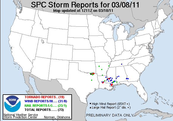
     Last Friday, I headed out on a 3 day chase adventure with Brandon Sullivan and Connor McCrorey. We targeted a bit southwest of the OKC area, being models were showing a discrete supercell firing to the southwest.  We stopped in El Reno for some pizza before the chase, and met up with Tony Laubach, Colt Forney, Kevin Rolfs, Scott Peake, and others. Towers began to go up shortly after finishing our pizza, and we decided to head northeast.

    After sitting in a field watching towers trying and dying, I began to get a little nervous. However, a tower just to our west was able to break the cap, and rapidly became a monsterous supercell.


   This storm was a very beautiful storm, however it just didn't have what it took to produce. It came very close for a little bit, and despite the plethora of reports of funnel clouds and rapidly rotating wall clouds, OUN didn't seem to want to tornado warn it.

This should probably be tornado warned...


   After watching this beast for a few hours, it became apparent it probably wasn't going to produce. However, it did drop a good sized swath of 3"+ hail, and was very photogenic. We eventually decided to start heading north to set up for Saturdays target, but got sidetracked shooting lighting. As we were shooting lightning, the storm we were shooting went tornado warned. We decided to head a bit south and west to check it out.

N Oklahoma Tor Warned Supercell around 10 PM
   After sitting in a field watching this beast for a while, we began to head back to I-35 when it appeared the tornado threat was diminishing. When we were just about back to the highway, an intensifying couplet began to appear on radar, so we started heading north to see if we could see anything. As we were driving north, we began seeing a cone-like feature in front of us every time it was backlit by lightning. As we got closer, it became more and more apparent it was probably a tornado, or extremely low and immense funnel. We got very close and experienced 70+ mph winds, and saw a semi nearly take out a row of cars parked on I-35, trying not to drive into a possible tornado. This storm went on to produce at least one tornado to our east, however we decided to ditch it to get in position for Saturday.

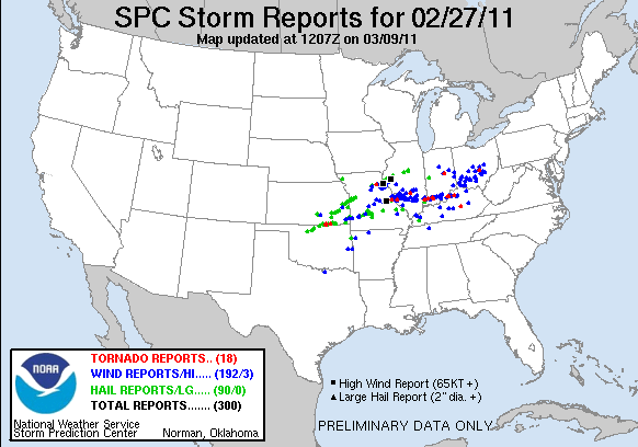
   We made it to Topeka early Saturday morning, and slept a few hours. We then headed to Omaha to pick up Brett Wright from the airport. We then decided to get Pizza Hut again, being we'd had luck every time we had eaten there before a chase. We looked over data over a few pizzas, and headed out. After watching a Cu field on satellite for a while, we began to see the towers in the distance. We decided to head a bit closer to get a better look. We watched one of the towers begin to dominate, and eventually grow into a monster supercell just NW of Omaha.

   After going through a few splits, the right split seemed to be getting it's act together. It strengthened, and then rooted itself into the warm front. It then turned hard right, and began to look like it may produce. We stopped in Mapleton, Iowa for a fill up, and the storm went tor warned. We headed a bit to the west to get a better look, and may have seen a few brief spin-ups. The inflow at our location was so strong, it ripped the drivers door open, and bent the hinges. We couldn't get the door shut, so I ended up tying it shut with my shoelaces in hopes of salvaging at least one tornado.


Video shot by Brandon Sullivan Wicked Wind Media
   Shortly after the door incident, we found ourselves watching a nice cone funnel come down with a little dust getting kicked up underneath. It rapidly intensified, and became a 3/4 mile wide EF3. Unfortunately, it hit the town of Mapleton, where we had just filled up. We decided to head into town to see if we could do anything to help, and try to figure out a way to fix the door for Sunday's chase.


   We stayed in Mason City, Iowa Saturday night and planned for Sunday. We decided to head to the La Crosse area. Brandon did an interview with Canadian National News in La Crosse, and then we decided to head a little north and west towards Tomah, WI. Storms began to fire quickly, and a PDS Tornado Watch was issued. We watched  a spectacular show on radar as several supercells split and merged with each other over and over. Our target storm quickly became tornado warned. We saw at least one tornado early on, however weren't able to get any good photos or video due to fast storm speeds and excessive amount of trees.


   Later on, we got some absolutely incredible structure. The storm eventually produced several tornadoes for us, but the amount of trees made it nearly impossible to shoot any photos or video. NEVER EVER CHASE IN NORTH WISCONSIN UNDER ANY CIRCUMSTANCES EVER!!! After seeing what appeared to be a huge wedge cross a few miles in front of us, we decided to just about give up... when we got a radar update showing an intensifying couplet just to our west. We sat still and watched a wall cloud spin across the road in front of us, but it just couldn't put anything down. Due to a lack of roads and how far north we were, we decided to call off the chase and begin heading south to Rockford to stay at my parents house.

   It was a great weekend, however it could have gone better. Unfortunately due to the door issues Saturday, we missed 10+ tornadoes after dark, including a violent wedge, twin stovepipes, and a multi-vortex tornado. I've even heard rumors that there was 3 tornadoes on the ground at one point. That storm is definitely one of the most powerful storms I've ever witnessed... and is likely one of the most powerful on record. Congratulations to everyone who got some amazing video and pictures of these spectacular nighttime tornadoes! At least I got to end the trip nicely by spending a night at home and seeing my best friend, Sputnik!

Sputnik

    It now appears that tomorrow could be a fairly significant severe weather outbreak across parts of the Southern Plains/Ozarks. A line of discrete supercells could develop along a dryline from SE Kansas to NE Texas in the evening. Tornadoes, some strong, are possible with any supercell that is able to develop. Potential may ramp up a bit towards sundown due to a strengthening low level jet around 00z to 01z. I currently like Central to East Central Oklahoma due to the positioning of the jet max, enhancing lift due to the left exit region over this area. SPC has issued a Moderate Risk, and I've been having good luck with those lately. If you live in areas affected by this system, pay attention to watches and warnings and stay tuned to local news or NOAA weather radio for more info.

Donovan Gruner

Tuesday, April 5, 2011

One of the Biggest Severe Weather Events of All Time

   Yesterday was one of the biggest and most widespread severe weather events of all time, with 20 reports of tornadoes, nearly 900 reports of damaging wind events, and nearly 200 reports of severe hail greater than 1 inch in diameter. These reports came in from nearly 20 states stretching from Texas to Florida, and up to Pennsylvania. This was easily one of the biggest severe weather events as far as coverage and number of reports in the last 5 years.

    This weekend appears that it will be another active weekend. Things will likely kick off in the Central Plains on Thursday, and several rounds of action on the dryline are expected through Sunday. At the moment it appears the threat could reach from Texas, Oklahoma, and Kansas up to Illinois, Iowa, Missouri, and Indiana. More updates to come as the event draws near.

Donovan Gruner

Monday, April 4, 2011

April 3rd, 2011 NE Kansas Chase

Supercell West of Topeka, KS
   Sunday was a very interesting chase day. I headed out with Connor McCrorey and David Reimer of TexasStormChasers.com. Originally we targeted somewhere near Emporia/Ottawa, Kansas. After deciding to head further north, we spotted towering cumulus development to our west. After watching it rapidly develop for several minutes, we began getting echo top returns on radar. Being that the storm was north of the cold front, we were skeptical if we should go to it at first... until we noticed something very unusual. It had appeared the storm was bending the cold front to allow for it to pull inflow from the warm sector to the south of the front! The storm rapidly intensified into a beast. It produced large hail and possibly the most intense gustnado of all time, near Perry, KS.

Just west of Lawrence, KS... Base becoming visible to the left.
Gustnado near

This is the first storm we were on. A classic supercell, you can see it modifying the cold front to allow for inflow to come from the warm sector. This radar image is roughly 15 minutes before the gustnado was observed.

   After the first storm began to move into the KC Metro area, we decided to intercept some hailers developing along the cold front/dryline.

   This was a very fun chase, with some very photogenic moments. I just regret not trying to get closer to the gustnado!


Donovan Gruner

Saturday, April 2, 2011

Tornado Outbreak Potential Tomorrow- N Illinois to N Texas

S WI 7-22-10


   It is beginning to appear that tomorrow's potential outbreak could be more widespread than initially thought. With moisture streaming further northward, the potential for tornadoes could reach as far as Northern Illinois. The main question of the day remains the location where the cap might be able to break due to a temperature inversion around 700mb.

CAPE 00z Monday
    At the moment it appears the two most likely areas for diurnal convection may be from E Iowa/N Illinois and E Kansas. However, if the cap should break Sunday evening anywhere from N Texas to Iowa, supercells will be possible with tornadoes and large hail. 
 
0-3 km Energy Helicty Index 00z Mon

SREF Sig Tornado Ingredients Parameter targeting N Illinois
NAM Sig Tornado Parameter targeting SE Kansas, NE Oklahoma, and N Illinois
   At the moment I am partial to E Kansas due to it being close to a triple point and a more realistic chasing target for me. However, I do like the potential in N Illinois. If it wasn't for classes on Monday, I would want to chase on my favorite terrain/road network in the country in N Illinois.

   This could potentially be a significant outbreak, so people across the Midwest and Central/Southern Plains need to be paying attention and reviewing severe weather safety before this event. Stay tuned to local news outlets and NOAA weather radios for up to the minute details.

Donovan Gruner

Thursday, March 31, 2011

Significant Severe Weather Possible This Weekend and Likely Next Week

Damage in Yazoo City, Missisippi in April of 2010 from an EF-4 tornado with a path length of 149 miles
   This weekend it appears possible that the threat of severe weather may return to the Great Plains.  Things could kick off as early as Saturday and Sunday, however Monday through Wednesday seems to be much more ominous.

   Saturday may bring a chance for a few severe storms in N TX.  These storms would likely be supercellular structures, and would have the potential to produce very large hail, and less likely an isolated or possibly few tornadoes. The main question at the moment is if enough moisture will be available in the area with the greatest potential, and if the cap will be able to break before nightfall when convective inhibitation will substantially increase and likely kill off any storms that may form during the afternoon hours.

   Sunday may also pose the threat for supercells along the dryline from southcentral to southeast Kansas through Central/East Oklahoma down to Central/East Texas. This setup has much more potential than Saturday, however the cap seems to be the main question for this setup as well. Any storms that form along the dryline will likely be extremely powerful supercells, and will have the potential to produce very large hail given CAPE possibly reaching 3000+ j/kg, and tornadoes- possibly strong, due to good wind shear and the high CAPE values along and ahead of the dryline. Again, the main question is if storms will be able to develop due to 700mb temperatures being on the high side, forming a capping inversion.

   As of now, it appears a large and very dangerous tornado/severe weather outbreak is likely Monday across parts of the Arklatex reigion into Dixie Alley. This setup could potentially be the first high risk setup of 2011.  Strong wind shear of 50+ kts and CAPE values exceeding 2000 j/kg should be enough to support supercells and bowing segments capable of producing large hail, damaging winds, and isolated tornadoes. Over parts of Dixie Alley, 850mb winds could be in excess of 50+ kts, pointing out the extreme energy this system will have. This severe weather event could even effect areas as far as Ohio, Indiana, Kentucky, Tennessee, and Illinois. This could be an especially dangerous day, so people need to pay attention to what is going on. As Monday comes closer, details will become more apparent, resulting in greater confidence in the forecast.

   This system will likely continue to produce severe weather across the south into New England Tuesday and Wednesday before exiting into the Atlantic. If you live in any of the affected areas, stay tuned to later forecasts and listen to NOAA Weather Radios and local news for more details regarding this event.

Donovan Gruner

Tuesday, March 22, 2011

Severe Weather Expected From Central Plains to Midwest

    Severe weather including tornadoes is possible today from parts of Kansas, Nebraska, Missouri, and Iowa.  Unlike previous days, it appears that stronger forcing and lower temperatures aloft will allow for the cap to be broken. A low pressure system/triple point will move into NE Nebraska and W Iowa by this afternoon, bringing the greatest severe weather potential due to veering low level winds near the triple point to the area.

300+ 0-1 km Helicity Across much of the risk area

    Low level helicity will be maximized by low level veering winds near the triple point, bringing the greatest tornado potential to SE Nebraska, NE Kansas, extreme N Missouri, and much of Iowa.

Maximized instability near triple point


    By 19-21z (2-4 pm CDT) storms are expected to be developing along the dryline from E Nebraska down through NE Oklahoma. The greatest tornado potential will be with any storms that are able to remain discrete for a while after development. Strong forcing associated with a shortwave trough may be conducive of a more dominant bow echo mode towards evening and sunset. This will shift the primary threat from large hail/tornadoes to damaging winds, which with some large hail could persist into the night through Iowa and N Missouri into Illinois. This system could also bring significant severe weather to parts of the East Coast tomorrow.

   Later in the week could bring more severe weather from parts of the southern and central plains, bringing more opportunities to chase Thursday through the weekend.

Donovan Gruner

SPC Tornado Probs

Wednesday, March 9, 2011

March 8th, 2011 N Texas Storm Pictures

First lightning shot of 2011!
   Another chase opportunity before heading home for spring break.  Headed out from Norman a little after noon (later than planned) and set a target of Sherman, TX to allow a little cushion to the west, since I expected storms to initiate just west of I-35 in N Central Texas.  Because of the late start, had to play catch-up with the storms as they developed slightly earlier than I had anticipated.  Once I finally caught up, it didn't take long for stuff to get interesting.

First hailstone to hit me in the noggin in 2011
   The first storm I got on was actually originally just a core punch to get into position for a more southern cell I was interested in.  Shortly after I began driving into the storm, the NWS slapped a Severe Thunderstorm Warning on it.  It produced gobs and gobs of dime to nickel sized hail, and torrential downpours.  After a while, stuff started looking more interesting on radar, so I decided to stick with it for a bit.  Eventually, I got into what there was of a "bears cage," and found a decent lowering.  It, however, did not appear to have much, if any, rotation at this point.  Within ten minutes of that, there was a rapidly intensifying couplet nearby, and giant hail began to fall.  The stone pictured above is the one that hit me in the head while trying to pick up a bigger stone from my open car door.  Some were around 2.5 to 3 inches, judging by what I could see on the ground.  One managed to put a small crack in my windshield, but luckily no more than just a small crack.  Also experienced some extreme winds, likely associated with a tornadic circulation/RFD, just to the west of Paris, TX.  There was a bit of damage done in the area of Paris to a small farm house and a barn. At this point I decided it would be too dangerous to continue being there was no paved roads to get further south of the storm, and it appeared to be completely rain-wrapped. If storms had stayed more discrete, there is no question in my mind that there could have been several more tornadoes, and a much better chase opportunity.


Sunday, March 6, 2011

Pictures from the February 27th, 2011 Northern Oklahoma Supercell


   Last week we headed out to N Oklahoma for the first chase of 2011.  Rang in the new chase season with a beautiful supercell that formed in NW OK and moved along a warm front into S C KS.  This storm produced a tornado near the OK/KS border just east of I-35. Unfortunately due to bad roads, we were unable to keep up with this beast being it was moving between 50-55 mph at that point. All in all, it was a great day to start off the 2011 storm season.


Storm Reports from 2/27/11

Saturday, February 26, 2011

Another Bout of Severe Weather Likely for the Southern Plains/Dixie Alley

Another strong system is moving into the Southern Plains and bringing 
with it chances for severe weather, including damaging winds, large 
hail, and strong tornadoes. There will also be a threat for extreme 
fire danger in the Texas Panhandle region into West Oklahoma behind 
the dryline.
 
  The main question remains the timing of this event. The warm sector 
will remain capped throughout much of the day; however it appears that
a corridor of CAPE values around 1000-1250 j/kg may be sufficient to 
break the cap before sundown. In this event, there is a threat for 
isolated tornadoes and very large hail, especially on storms that form 
early, as they will likely remain isolated until a short time after 
sundown. The system is then expected to expand in coverage and likely 
quickly evolve into a QLCS type system,much like Thursday night's event. 
There will then be a threat for mostly widespread damaging winds, however 
a tornado threat should exist well into the night with any semi-discrete 
or embedded supercells in the line. This could once again be a very 
dangerous evening/night for parts of the Southern Plains and Mid-
Mississippi River Valley into Dixie Alley.


Thursday, February 24, 2011

Severe thunderstorm watch for w texas and west and central oklahoma until 11 am

Tuesday, February 22, 2011

First Major Severe Weather Outbreak of 2011 Possible Thursday!

System drawing moisture from the Gulf
It appears probable that a fairly significant severe weather outbreak is taking shape for Wednesday night into Thursday. A low pressure system will move through the Southern Plains into Dixie Alley Wednesday night into Thursday afternoon and evening. It appears an early round of thunderstorms across W Oklahoma could will develop Wednesday night, and move across the state through morning. This first round of storms main threat will be large hail and possibly damaging winds. Thursday afternoon, storms are expected to form ahead of a dryline bulge and along a warm front across E Oklahoma. Along with large hail and damaging winds, isolated tornadoes will be possible with these storms. At the moment, it appears the greatest threat for severe weather will begin in Central Oklahoma and move across the state into Arkansas. The severe weather threat could continue eastward overnight, although instability will be limited, so the main threat will probably be damaging winds. Stay tuned for further information regarding this event.

Day 3 Convective Outlook Valid Thursday, 2/24

Tuesday, February 8, 2011

Another Round of Snow Expected for the Southern Plains

    Another round of snow is expected today through tomorrow in parts of Kansas, Oklahoma, and Texas, as well as surrounding areas. This comes a week after the crippling snowstorm that hit the same areas, making travel nearly impossible last week. Just as these areas recovered, there may be a significant snowfall tonight through tomorrow afternoon as well. The heaviest snow is expected to be in areas of Southern Kansas into Central Oklahoma, where 6 to 10 inches of snow is possible, with isolated areas receiving up to a foot of snow.

    Although this could be a fairly major storm, there does seem to be some hope for warm weather. Temps are expected to rise into the lower to mid 60's by Sunday, and continue through next week. This will bring much needed relief to areas affected by this storm and last weeks storm.

    If traveling in any of the affected areas tonight or tomorrow, use extreme caution, and stay updated on the latest weather forecasts.

Donovan Gruner

Monday, January 31, 2011

"Snowpocalypse". Historic Storm Upon Us?

    This could be a record breaking or near record breaking storm for much of the country.  Latest model runs put a band of extremely heavy snow over Central Oklahoma into SE Kansas. Some areas from Oklahoma City to Chicago are expected to receive at least a foot of snow, and locally some areas may receive up to 2 feet! Strong winds will also complicate things, and areas that receive the highest amounts of snow could see snow drifts up to 8 feet or more. Blizzard Warnings are in effect in 7 states, and reach from Oklahoma City to Chicago and Milwaukee.


    The southern edge of the storm will bring significant icing to areas along the I-44 corridor in Oklahoma and especially Missouri. The ice threat also stretches across Illinois to New England. Some of the hardest hit areas will be St. Louis, Indianapolis, and Pittsburgh.

Ice Accumulations Through Wednesday

    This is a very dangerous storm, and many areas can expect major power outages along with incredibly heavy snow, freezing rain, sleet, and bitter cold wind chills. Several states including Oklahoma, Missouri, and Illinois have been declared to be in a State of Emergency. Stay tuned to your local news and NOAA Weather Radios for up to date details on the storm, and DO NOT travel unless ABSOLUTELY neccesary. If travel is unavoidable, dress in layers and bring food, water, and blankets in case you become stranded. This is a life threatening situation.

What the NWS has to say in it's Forecast Discussions:
   
      Norman, OK: Obvious analog would be Christmas Eve '09. For some this may be as bad or worse.  (That was Okla. City's record snowy day...13.5")
   
      Kansas City, MO: "This could end up being one of the more significant weather events in the last 20 years in Missouri."
   
      St. Louis, MO: "Potentially historic winter storm headed for region."
   
      Milwaukee, WI: Potentially "paralyzing blizzard" possible in southeast Wisconsin. Jan. 1999 blizzard produced 4-8 foot drifts!
   
      Grand Rapids, MI: "Travel...and commerce in general...could be paralyzed with near record-breaking snowfall."
   
      Indianapolis, IN: "(Ice and blizzard conditions) could result in devastating conditions for central Indiana. Long duration power outages appear possible."

Donovan Gruner

Sunday, January 30, 2011

Extreme Winter Storm to Impact Much of the Country

     Strong disturbances associated with two jet streams will develop into a major winter storm for much of the country on Monday through the week. The jet stream is bringing very cold arctic air down from Canada and kicking off the storm by bringing moderate snowfall amounts to much of the Northern Plains and Great Lakes regions. To the south, a wintery mix will begin Monday night in the Oklahoma Panhandle and Southern Kansas before spreading eastward into Missouri. Snow will then begin falling over parts of Central Oklahoma Monday night into Tuesday. 

     A PDS (Particularly Dangerous Situation) Winter Storm Warning is in effect for Central and Northeastern Oklahoma.

     A Blizzard Watch is in effect for much of Northern and Central Illinois and Northwest Indiana, where strong winds and extremely heavy snowfall rates will combine to produce blizzard conditions. As much as 20 inches of snow at a rate of 3 inches per hour are possible in these areas.

GFS showing snow depth by Tuesday afternoon

NAM showing more extreme snowfall totals up to 20+ inches from Central Oklahoma through Missouri, Illinois and Michigan

Wednesday, January 26, 2011

Warm Air to Invade Southern Plains


Models are showing a "heat wave" moving into the Southern Plains at the end of the week, showing temperatures up to 70 degrees in many parts of Oklahoma and Texas. However, they are also showing a possible cold streak next week, with a possibility of a period of wintery precipitation.

Monday, January 24, 2011

November Tornado In N. Illinois As Shown By Radar


Photobucket

    Northern Illinois is beginning to grow accustomed to strange out of season tornadoes. On January 7th, 2008, an EF-3 tornado with wind speeds as high as 160 mph ripped through Boone and McHenry Counties.  Then, on November 22nd, another strange out of season tornado touched down, in nearly the same place. Had it touched down earlier, however, we may have had an entirely different situation on our hands.

11/22 tornadic supercell with visible BWER (bounded weak echo region, area of lower reflectivity sw of Loves Park and nw of Rockford) associated with the storm's updraft, and sometimes a precursor to tornadogenisis.


    These radar images (Storm Relative Velocity) depict the motion of particles within the storm. The doppler radar is able to detect this the same way as a police radar detects the speed of a vehicle. Meteorologists are able to use this product to detect rotation within thunderstorms, and sometimes detect tornadoes.


    This is the SRV at 2:51 pm. Although the radar is picking up some rotation just northwest of downtown Rockford, there is no tornado warning, possibly because the rotation isn't quite strong enough to validate a warning at the time. HOWEVER:

     Seen here is the same storm, but viewed at a higher elevation, ten minutes earlier (2:41 pm). There is very strong rotation at around 13kft, just southeast of Winnebago.

      Here you can clearly see the meso tighten up. This is at about 6,500 ft. The velocity couplet is now exhibiting strong maxed out velocities in both directions. This image is at about 2:56 pm, four minutes before the tornado warning was issued.
      At 3:00 pm, the NWS Chicago issued a tornado warning for Winnebago, Boone, and McHenry counties...

THE NATIONAL WEATHER SERVICE IN CHICAGO HAS ISSUED A* TORNADO WARNING FOR...
NORTHERN BOONE COUNTY...
NORTHWESTERN MCHENRY COUNTY...
EAST CENTRAL WINNEBAGO COUNTY...
* UNTIL 330 PM CST
* AT 300 PM...NATIONAL WEATHER SERVICE DOPPLER RADAR INDICATED A
SEVERE THUNDERSTORM CAPABLE OF PRODUCING A TORNADO. THIS DANGEROUS
STORM WAS LOCATED NEAR LOVES PARK...AND MOVING NORTHEAST AT 50 MPH.
* LOCATIONS IMPACTED INCLUDE...
HARVARD...POPLAR GROVE AND CAPRON.
PRECAUTIONARY/PREPAREDNESS ACTIONS...
TAKE COVER NOW. MOVE TO AN INTERIOR ROOM ON THE LOWEST FLOOR OF A
STURDY BUILDING. AVOID WINDOWS. IF IN A MOBILE HOME...A VEHICLE OR
OUTDOORS...MOVE TO THE CLOSEST SUBSTANTIAL SHELTER AND PROTECT
YOURSELF FROM FLYING DEBRIS.
&&
LAT...LON 4249 8856 4240 8846 4222 8895 4238 8909
4250 8888
TIME...MOT...LOC 2103Z 237DEG 42KT 4236 8892

     Unfortunately, judging by radar images, this warning was only issued about a minute or possibly less before the tornado was on the ground.


      This image shows the tight circulation crossing I-39/90 at 3:00, when the first tornado warning was issued. The tornado touched down right around this area.

Tornado path very distinct just after I-39/90 (center of image) near Rock Cut State Park (right)
     At this point, reports were coming in of a tornado on the ground. The tornado continued on, mostly through fields, before reaching Caledonia.


     Here the velocity couplet is shown entering Caledonia. Most of the most devastating damage done by this storm was in the Caledonia area, where the tornado's winds were likely reaching up to around 135 mph or more.

Image as tornado moves away from Caledonia at 3:09 pm.


Tree damage at Beloit Rd.

    All in all, Rockford and surrounding areas lucked out big time on this one. If this tornado would have touched down even 5 minutes earlier, it likely would have ripped through parts of Rockford and Loves Park.  Ten minutes earlier, and it would have ripped nearly right across town. The damage would have been far worse, being more structures "strengthen" the tornado in a way, giving it more power by turning it into a massive "blender".  Not to mention, it would have moved through a much more heavily populated area.

    Although the tornado did do quite a bit of damage in Boone and McHenry counties, luckily nobody was seriously injured. This storm also went on to produce an EF-1 tornado just over the state line.


Donovan Gruner